

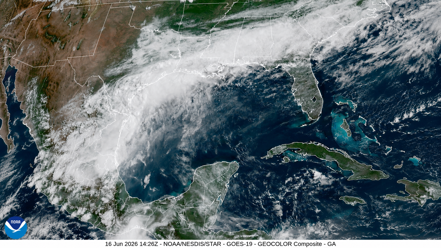
Tropical Storm Watches are flying for portions of the Upper Texas and southwestern Louisiana coasts as a slow-moving tropical disturbance located just inland along the south Texas coast on Tuesday morning could move offshore and develop into a tropical storm before heading back over land later this week. Heavy rains have already drenched this flood-prone area well ahead of the tropical disturbance, and additional totals could exceed 10 inches by late this week.
Invest 90L, which was officially designated Potential Tropical Cyclone One at 11 a.m. EDT Tuesday by the National Hurricane Center, is a disturbance being monitored for potential tropical development and has been under observation for several days. The NHC designates this as a Potential Tropical Cyclone (PTC) because it is not yet a tropical depression or tropical storm (with a well-defined center of circulation) but is close enough to land to produce significant impacts. The PTC designation allows the issuance of tropical storm watches and warnings.
The name itself will not be as important as the impacts it could bring to the Texas Coast and possibly other parts of the Gulf Coast this week, even before it could officially be named Arthur. For reference, on average (1991–2020), the first named storm of the Atlantic hurricane season receives its name by June 20. Regardless of whether this system officially receives a name or remains a Potential Tropical Cyclone, residents along the Gulf Coast should remain prepared for heavy rainfall this week. Flooding will be a significant threat and could become life-threatening very quickly.

Satellite imagery indicates that the system’s center remains over land near South Texas. While the center remains inland, it has little chance of developing into a tropical system. However, it could move over the Gulf waters later Tuesday or Wednesday near the Texas Coast, where relatively warm sea-surface temperatures and favorable atmospheric conditions could support the development of a brief tropical system. Water temperatures in this region near South Texas are at least 83.5°F (29°C). Do not underestimate the impacts of what may be a short-lived system. As it tracks along the Texas Coast, it will bring abundant tropical moisture, heavy rainfall, and gusty winds to areas already saturated by recent storms and downpours (more on this below).
What are the models showing?

Forecast models remain somewhat inconsistent regarding the system’s exact location and level of organization. The GFS (American model) depicts a brief closed circulation developing later today just southwest of Corpus Christi, with the deepest convection spreading along the southeast Texas Coast and into southern Louisiana through Thursday morning. Rainfall projections indicate the highest totals will be concentrated across parts of southern Louisiana and southern Alabama, with isolated locations receiving more than nine inches of rain.

The European model suggests somewhat greater organization, with convection impacting much of the Texas Coast while keeping the circulation broad and hugging the central and southeastern Texas coastline through Wednesday afternoon. This model also indicates that the most intense thunderstorms will affect much of the Deep South, producing a significant rainfall event during the second half of the week. Rainfall totals could exceed six inches across many areas from Southeast Texas through Louisiana, Mississippi, and Alabama. All this rain would be on top of what has already fallen in recent days.
Flash flooding struck central Texas on Sunday night, June 14-15, closing Interstate 35 in both directions in Waco.
🌧️ A surge of tropical moisture turned parts of Waco into a flood zone Sunday night.Slow-moving thunderstorms dumped rain at rates of 2 to 4 inches per hour, triggering widespread flash flooding across the Waco area.

One sign of the soggy atmosphere flowing across the Texas coast and into the torrential rainstorms: The amount of moisture (precipitable water) in an imaginary column above Corpus Christi, Texas, reached 2.74 inches (6.97 centimeters) on Monday night, as measured in a weather-balloon sounding. This is the ninth highest value measured across more than 50,000 soundings collected in the Corpus Christi area over the past 73 years, and it’s the highest on record there outside of the core summer window from late June through late September.
The surface waters of the western Gulf of Mexico aren’t especially warm for mid-June right now, with near-average temperatures for this time of year. However, this disturbance is drawing on a pool of very rich atmospheric moisture flowing northward from Central America and the eastern tropical North Pacific. Sea surface temperatures in the latter region are at record seasonal highs, the result of a months-long marine heat wave off the Pacific coast of Mexico combined with equatorial warming from El Niño’s arrival.

Some recent and unsettling precedents for massive TX/LA tropical rains
Southeast Texas and southwest Louisiana are no strangers to gully-washing, neighborhood-inundating rainfall. Sometimes it’s because of a powerful hurricane that stalls, as with Harvey in August 2017. After crashing into southern Texas as a Category 4 powerhouse, Harvey weakened into a slow-moving tropical storm that lingered for days near the upper Texas coast. Harvey dumped an estimated 24.5 trillion gallons of rain in Texas and Louisiana. The storm total of 60.58 inches at Nederland, near the Texas-Louisiana border, was the largest on record for any tropical cyclone in the 48 contiguous U.S. states.
Even storms that never become hurricanes have produced major disasters in this area. In July 1979, the heaviest 24-hour rainfall on record for the contiguous U.S. — an astounding 42 inches—deluged Alvin, Texas, just southwest of Houston, in association with Tropical Storm Claudette. Far more damage occurred with slow-moving Tropical Storm Allison in June 2001, which flooded some 70,000 homes in the Houston area. Allison’s multi-day onslaught took 50 lives and left $8.5 billion in damage (USD 2001).
More recently, Tropical Storm Imelda peaked with sustained winds of only 45 mph before coming ashore and weakening across southeast Texas in September 2019. Yet Imelda dumped more than 40 inches of rain in some areas, triggering massive rescue efforts and wreaking some $5 billion in damage (USD 2019). And in August 2016, the “no-name” tropical disturbance over Louisiana dumped over 31 inches of rain, generating flooding that killed 13 and left $14 billion in damage (USD 2026).

Welcome drought relief on the way
While it would be preferable if the coming rains along the Gulf Coast were not so extreme, they will provide a significant positive benefit in the form of drought relief. While the latest short-term drought data show much of the region has recently pulled out of a months-long drought which peaked in March, the region has been experiencing a years-long precipitation deficit that has seriously depleted groundwater and reservoirs. This has forced the city of Corpus Christi to consider emergency water restrictions this summer. As of June 13, the central and upper Texas coast needed 19-20 inches of rain in just one month to pull them out of intense long-term drought conditions, according to NOAA (Fig. 2). The situation was even worse for Florida (outside of the Panhandle), where 20-26 inches was needed.
A May 20 story in Inside Climate News reported that Corpus Christi’s largest source of water, the Choke Canyon Reservoir, hasn’t been full since 2008, and “has received three minor inflow events and zero major inflow in the last 15 years, according to Texas state climatologist John Nielsen-Gammon. The next-largest reservoir, Lake Corpus Christi, hasn’t logged inflows in five years. Both reservoirs combined are about 8 percent full.”

Further to the south and west, generous rains across Mexico so far this year have brought dramatic drought relief there. In recent weeks, the fraction of Mexico experiencing abnormal dryness or drought has dropped to around 15 percent, the lowest value since 2015.
Jeff Masters and Bob Henson contributed to this post.
This <a target=”_blank” href=”https://yaleclimateconnections.org/2026/06/heavy-rains-slam-the-texas-coast-ahead-of-potential-tropical-cyclone-one/”>article</a> first appeared on <a target=”_blank” href=”https://yaleclimateconnections.org”>Yale Climate Connections</a> and is republished here under a <a target=”_blank” href=”https://creativecommons.org/licenses/by-nc-nd/4.0/”>Creative Commons Attribution-NonCommercial-NoDerivatives 4.0 International License</a>.<img src=”https://i0.wp.com/yaleclimateconnections.org/wp-content/uploads/2020/10/ycc-favicon.png?resize=100%2C100&ssl=1″ style=”width:1em;height:1em;margin-left:10px;”>
<img id=”republication-tracker-tool-source” src=”https://yaleclimateconnections.org/?republication-pixel=true&post=139564&ga4=1401ERFF5Q” style=”width:1px;height:1px;”><script> PARSELY = { autotrack: false, onload: function() { PARSELY.beacon.trackPageView({ url: “https://yaleclimateconnections.org/2026/06/heavy-rains-slam-the-texas-coast-ahead-of-potential-tropical-cyclone-one/”, urlref: window.location.href }); } } </script> <script id=”parsely-cfg” src=”//cdn.parsely.com/keys/yaleclimateconnections.org/p.js”></script>