


In brief
- The strongest hurricanes are getting stronger as a result of climate change.
- Warmer ocean waters may enable more hurricanes to form near the U.S. coast, increasing the number of U.S. landfalls.
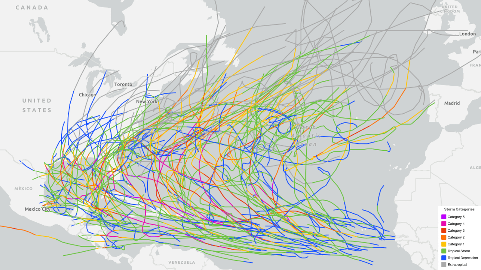
- No significant north-south or east-west changes in the tracks of named Atlantic storms have been reliably detected in recent decades, though there appears to have been a significant shift to the south for storms attaining hurricane strength.
- We should distrust climate models that show a future eastward shift in steering currents that would lessen the landfall risk for the U.S. and Caribbean, because the same models have failed to accurately capture the influence of climate change on El Niño and La Niña.
It’s well established that the strongest hurricanes on our warming planet are getting stronger, intensifying more quickly, and dumping more rainfall. And the Atlantic has been spitting out more tropical cyclones overall since the 1990s. But what do we know about where those hurricanes will form and where their tracks will go as the climate changes? Since hurricanes are the most destructive storms on the planet, the answers to those questions are of grave importance to East Coast, Gulf Coast, and Caribbean residents.
The short answer is that scientists have a lot left to learn about how climate change will affect hurricane storm tracks, and our current climate models are likely producing misleading results on that question.
More hurricanes may form near the U.S. coast, increasing the number of landfalls
As the waters near the U.S. coast warm because of climate change, we might expect that an increasing number of hurricanes could form in waters that were formerly too cool. A 2022 modeling study, Dynamical downscaling projections of late twenty-first-century U.S. landfalling hurricane activity, used the Intergovernmental Panel on Climate Change’s models from 2010-2014 to show that a warmer climate will indeed increase hurricane genesis near the U.S. coast, resulting in an increase in the proportion of hurricanes making U.S. landfall. The study also found that a change in climatological steering currents would favor more U.S. landfalls.
A 2021 study, Evolving Tropical Cyclone Tracks in the North Atlantic in a Warming Climate, used the IPCC CMIP5 models to predict hurricane tracks for 2080-2100 under an extreme global warming scenario (RCP8.5, for those in the know). The scientists reasoned that since the position of the band of active tropical thunderstorms often involved in spawning hurricanes, the Intertropical Convergence Zone, can be expected to shift northwards as the climate warms, this “could help drive increased density of hurricane genesis along the U.S. southeast coast in the future.” In fact, geologic records suggest an elevated level of hurricane activity along the U.S. East Coast 1,000-2,500 years ago, when the Intertropical Convergence Zone was farther north.
The paper showed that hurricanes affecting the Northeastern U.S. would be more likely to form near the coast in an area just offshore of the U.S. Southeast coast. Formation near shore would potentially limit lead time before a hurricane landfall, increasing damage and potential loss of life.
Compared to the pre-industrial climate, the results showed a decreased risk of hurricane landfalls in New York City, an increase for Norfolk, Virginia, and little change for Boston. Future storms moving along the East Coast would likely move more slowly at landfall, increasing their damage potential by subjecting the coast to a longer period of impacts, particularly for Virginia and North Carolina.
One potential such harbinger storm of the future occurred in August 2021. A powerful low-pressure system caused $1.1 billion in severe thunderstorm damage in the Midwest and mid-Atlantic before moving over the warm ocean waters off the mid-Atlantic coast. After festering over unusually warm waters near Bermuda, this system developed into Tropical Storm Henri, which gradually strengthened to a Category 1 hurricane with 75 mph winds, prompting hurricane warnings for the coasts of New York, Connecticut, Rhode Island, and Massachusetts.
Fortunately, Henri moved unusually slowly for a New England hurricane, and as it approached the coast, much cooler waters there were able to weaken it to a 60-mph tropical storm by the time of its landfall in Rhode Island. Still, Henri’s slow forward speed of 11 mph at landfall resulted in torrential rains, a significant storm surge, and $650 million in damage.

Observed changes in hurricane tracks in recent decades: no clear consensus
Natural changes in Atlantic hurricane tracks occur on decades- and century-long timescales. For example, paleotempestology studies of sediments laid down by hurricane storm surges found that in 600-800 A.D., fewer hurricanes were detected in New England, while more frequent hurricanes hit the Bahamas and Florida. In general, it appears that historically the Atlantic has flipped between two dominant modes, one favoring hurricane landfalls in the southwestern Caribbean and Gulf of Mexico, and one bringing increased landfall activity to the eastern U.S. A switch between the two modes can occur randomly, or because of large-scale climate shifts in sea surface temperature patterns. A 2010 modeling study, Future Change of North Atlantic Tropical Cyclone Tracks: Projection by a 20-km-Mesh Global Atmospheric Model, predicted that global warming would cause a shift in hurricane tracks to favor the mode favoring landfalls along the U.S. East Coast, primarily because of a shift to the east in where hurricanes form.
We can expect human-caused climate change to influence hurricane tracks, given the large perturbations to fundamental atmospheric circulation patterns now underway. It is possible that some of the changes observed in recent decades (Fig. 2) may be from these influences. But as NOAA’s Global Warming and Hurricanes primer states, “no modeling consensus is yet available on whether or not such changes are detectable yet — and what changes might be expected in the future.”

A 2013 study, The Impact of Anthropogenic Climate Change on North Atlantic Tropical Cyclone Tracks, found that a future warmer climate might favor track shifts to the east in the Atlantic — away from landfalls in the Caribbean and North America — because of a shift in steering currents and a more easterly genesis location. A 2017 modeling study, Impact of climate change on New York City’s coastal flood hazard: Increasing flood heights from the preindustrial to 2300 CE, supported this idea for storms passing near New York City, finding that the storm track would shift to the east with increased global warming (Fig. 3).
One 2022 paper, Slower decay of landfalling hurricanes in a warming world, argued that such a shift may have already occurred for landfalling Atlantic hurricanes.
The study divided Atlantic hurricane landfalls during two 25-year periods (1967-1992 and 1993-2018) into an eastern and western region, with the demarcation line running from the Florida Panhandle southward off the west coast of Florida, through the Florida Keys, then just north of Cuba and Hispaniola. The study found that the position of where landfalling hurricanes have been hitting the U.S. and Caribbean coasts “has indeed seen a notable shift to the east in recent decades.” For the U.S., 76% of landfalls occurred in the western portion of the domain during the first 25 years, and just 54% for the more recent 25-year period.
However, since the 2018 data cutoff period of this study, there has been an increased number of landfalls in the more western portion of the Gulf of Mexico. If one divides landfalling continental U.S. hurricanes over the past 50 years into two 25-year periods (1976-2000 and 2001-2025), then divides them between the Gulf of Mexico and the Atlantic coast (Fig. 4), exactly two-thirds of all landfalls occurred in the Gulf of Mexico and one-third along the Atlantic coast for both 25-year periods. This suggests that there has been no significant east-west shift in landfalling U.S. hurricanes over the past 50 years.
The most remarkable change is that the proportion of major hurricanes making a U.S. Gulf of Mexico landfall has increased from 27% to 44% from 1976-2000 to 2001-2025. In contrast, the proportion of major hurricanes making a U.S. Atlantic coast landfall has decreased from four out of 11 (36%) to two out of 17 (11%) over the same period (though the lack of data points makes the significance of this reduction dubious).

When looking at all named storm tracks across the Atlantic (not just landfalling hurricanes), three papers have found no significant shifts. A 2021 paper, Recent migration of tropical cyclones toward coasts, found that the location where named storms in the Atlantic reached their lifetime maximum intensity from 2000-2018 compared to 1982-1999 did not show any significant shifts to the east or west, and only a small shift southward – by about 21 miles.
A 2021 paper, Recent migration of tropical cyclones towards coasts, found no significant shifts in east-west named storm tracks in the Atlantic from 1982 to 2018. And a 2014 paper, The poleward migration of the location of tropical cyclone maximum intensity, found essentially no trend northward or southward in the Atlantic named storm tracks from 1982-2012, but did not look at east-west shifts. A 2026 conference presentation, Are Tropical Cyclones Moving Northwards In the Atlantic?, found that the latitude at which Atlantic tropical cyclones attained their maximum winds has migrated northward at 93 miles (150 km) per decade since 1970. This research has not yet undergone peer review.
A 2025 paper, The southward shift of hurricane genesis over the northern Atlantic Ocean, found no significant north-south shifts to the genesis location for named storms in the Atlantic from 1979 to 2022. However, when considering just hurricanes, the research showed a significant shift southward of where these storms formed by 346 miles (557 km) over the 44-year period, and a southward shift of where they attained their lifetime maximum intensity (410 miles or 660 km farther to the south in the 44-year period).
This shift was attributed to global warming heating up the subtropical Atlantic faster than the tropical Atlantic, leading to a reduction in wind shear over the southern tropical Atlantic (between 10°-20°N). The southward shift in hurricanes may help explain why the mainland U.S. has not seen an increasing trend in major hurricane landfalls in recent decades, while non-mainland U.S. areas (primarily in the Caribbean) have (Fig. 5).

The research found no significant east-west shifts in the location where hurricanes first became hurricanes, or where they achieved their lifetime maximum intensity. There was a shift in their initial genesis location to the east by 2.52° longitude in the 44-year period.
To summarize these results, it is fair to say that a significant change in Atlantic named storm tracks has not been reliably detected in recent decades, though there appears to have been a significant shift to the south for storms attaining hurricane strength.

The role of El Niño
The El Niño-Southern Oscillation, or ENSO, has a major steering influence on Atlantic hurricanes.
During El Niño, the Azores-Bermuda High, the semipermanent area of high pressure over the central Atlantic that often is the main steering influence for hurricanes, tends to weaken and shift eastward. This causes earlier recurvature of storms, resulting in a lower track density in the Caribbean, Gulf of Mexico, and western tropical Atlantic, but an increased track density in the central and eastern Atlantic and at higher latitudes in the North Atlantic.
The reverse holds true during La Niña, which favors a stronger and more westerly position for the Azores-Bermuda High. Over the past 50 years, there have been over twice as many U.S. landfalling hurricanes and major hurricanes during La Niña compared to El Niño (though part of this difference is from higher wind shear during El Niño years, which reduces the total number of hurricanes).
As we wrote in 2023, top global climate models have predicted for more than 20 years that the tropical Pacific would gradually shift toward a more “El Niño-like” state, but the opposite has been happening (Fig. 7). Moreover, multiyear La Niñas have been increasing: A 2023 paper, “Understanding the recent increase in multiyear La Niñas,” found that there were only two multiyear La Niña events before 1970; these followed a neutral ENSO state.
Read: A new and better way to keep tabs on El Niño and La Niña
Since 1970, there have been eight multiyear La Niña events, and these always followed an El Niño. The reason? Unknown – although several studies in late 2025 found potential links between human-caused climate change and the increasing tendency toward La Niña.

A June 2024 paper, Crucial role of sea surface temperature warming patterns in near-term high-impact weather and climate projection, investigated using a single climate model (GFDL) what would happen to the number of tropical storms if the current observed trends in sea surface temperature patterns were to continue until 2100. Fig. 8 (left) shows what the unadjusted model says should happen in a 101-year simulation (a more El Niño-like climate in the future), while Fig. 8 (right) shows what would happen if the sea surface temperature trends observed from 1979-2020 continue into the future. The main takeaway: If the observed sea surface temperature trends continue, in defiance of what the climate models say should be happening, increased relative warming over the Caribbean Sea and relative cooling over the eastern tropical Atlantic will tend to shift North Atlantic hurricanes towards the Caribbean Sea and Gulf of Mexico, while the Atlantic coast from Florida to the Canadian Maritimes will see little change in hurricane activity.

Climate models don’t get El Niño right, so they can‘t be relied on to get future hurricane tracks right
If the IPCC models are indeed correct and the future climate becomes more El Niño-like, this would increase the risk of landfalling hurricanes along the U.S. Gulf and Southeast coast, according to a 2023 paper, Increased U.S. coastal hurricane risk under climate change. The increased ocean temperatures in the tropical Eastern Pacific relative to the Atlantic would drive an atmospheric circulation steering more hurricanes into the U.S. Gulf and Southeast coasts, and also reduce wind shear, allowing more intense hurricanes to form.
And while climate models tend to favor a shift in steering currents to the east that will lessen the landfall risk for the U.S. and Caribbean, we should distrust them, since they say global warming should result in a more El Niño-like climate, but the recent trend has been the opposite — toward a more La Niña-like state.
What to make of all of these seemingly contradictory and still-uncertain findings?
My hunch is that the current La Niña-like sea surface temperature pattern will continue for the next 30 or more years, in defiance of what the climate models say should happen. This would result in an increased risk of hurricanes affecting the Caribbean and Gulf Coast, with the risk relatively unchanged along the Atlantic coast from Florida to the Canadian Maritimes.
Bob Henson contributed to this post.
![]()