


It would have stunned those fortunate enough to see it in 1746 – a detailed map of London which showed a bird’s-eye view of the capital for the first time.
Now, John Rocque’s masterpiece ‘An Exact Survey of the Cities of London and Westminster, and the Borough of Southwark’ is being reproduced 280 years later.
The map by the French-born Huguenot cartographer used pioneering triangulation techniques to present the city and its rural surroundings in accurate detail.
His work across 24 sections gives a unique insight into Georgian London having been carefully conserved and the contemporary illustrations restored to pristine quality.
The map was based on an instrumental survey using a perambulator, also known as a surveyor’s wheel; and a theodolite, for measuring horizontal and vertical angles.
The new book, ‘London in the 18th Century’, from Atlantic Publishing features words from Wallace Crawford Snowdon, including history and illustrations for each section.
Mr Snowdon explores life in London in the 1740s, while identifying streets and buildings which still exist and plotting the course of major roads yet to come.
London was the country’s most intensely industrialised area and a global centre for trade at the time of the maps, when tall ships were seen sailing up the River Thames.

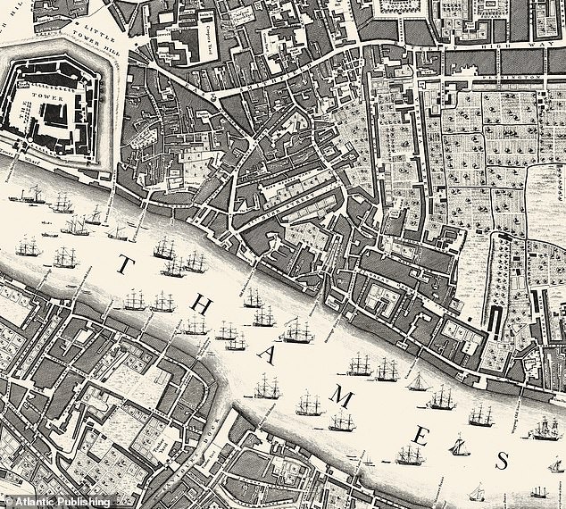
The area around the River Thames to the east of the Tower of London is shown in one section of the map by John Rocque in 1746 – nearly 150 years before Tower Bridge was constructed

The Hyde Park and Mayfair section of the map, with Oxford Street appearing as ‘Tiburn Road’

Marylebone Fields was an area of scrubland used for duels and hampered by highway men
A former version of London Bridge had 551 inhabitants in a period when only two bridges spanned the Thames and heads were seen on spikes outside Temple Bar.
People would travel to the capital to trade in coal, wool, cloth, meat and corn – and the city’s outskirts were Hyde Park, Marylebone, Vauxhall and Spitalfields.
Bermondsey was the centre of ropemaking, watchmakers were found in Clerkenwell and Marylebone was scrubland used for duels and hampered by highway men.
Weavers were based in Spitalfields, while Mile End was a small country town and Bethnal Green was a country retreat where gentlefolk went for fresh air, cake and ale.
Whitechapel was the city’s rubbish dump, and Bloomsbury had fresh water springs that were fed to water nearby Holborn.
Vauxhall was known for gardens where society would convene, while South London featured fields, orchards, inns, farms, timber yards and military camping grounds.
The new book is based on a 64-page paperback title released by the Daily Mail in 1947 called ‘London 200 Years Ago’, and is being published following improvements to printing techniques in recent decades.
This book was written by Mr Snowdon, a Fleet Street journalist whose text has been updated for the new version.
English Heritage historian Steven Brindle described the map as ‘almost miraculous’, explaining that Rocque would have worked with basic tools and two assistants.

A panorama of the City of London and the River Thames in 1751, five years after the map was published. The Tower of London is on the right, and St Paul’s Cathedral further down the river

Covent Garden Market, shown in a painting by Balthazar Nebot in 1737 which displays its Italian piazza bounded on the west by St Paul’s Church and on the other three sides by tall houses

The Thames and Fleet Canal in 1750, when central London was an intensely industrialised area

York Buildings Waterworks’ Water Tower in 1780, now part of Victoria Embankment Gardens

Westminster Abbey and St Margaret’s Church on the left are shown in this print from 1753

St James’s Park in the early 18th century which featured a long formal canal lined with trees

The first London Bridge as it appeared in 1757, before the houses on it were pulled down

The south prospect of the Tower of London in 1752 shows a series of boats on the Thames

The Grand Walk at Marybone Gardens, a pleasure garden in the grounds of a manor house

Soho Square, early in the 18th century, was a fashionable enclave with a statue of Charles II

A view of the Rotunda at Ranelagh Gardens, a public pleasure gardens in Chelsea, in 1751

Westminster Abbey from Tothill Fields, capturing a surprisingly rural scene in the area in 1832

Soho Square looking south to Monmouth House, the Duke of Monmouth’s 17th-century home

‘London in the 18th Century’ from Atlantic Publishing will be released on Thursday

The book is based on another released by the Daily Mail in 1947 called ‘London 200 Years Ago’
Mr Brindle told BBC News: ‘A chain, 66ft long, a surveyor’s wheel and a notebook, and they would go over, for example, a field, and they would measure it on all its sides, and they would draw that as accurately as they could.
‘It might be a few days’ work. And it’s really accurate. This is what almost seems miraculous when you understand how simple the tools he had to work with were.’
He added: ‘The City of London was packed with dense alleys and streets, a lot of them very insanitary. There were slums just a couple of streets away from really rich merchants living in their houses.
‘The city had large fields, orchards – and tall ships crowded the Thames. It’s all depicted on Rocque’s masterpiece created in 1746.’
Born in 1704, Rocque was descended from a Huguenot family who had once been small landowners in France but moved to Switzerland then England in 1709.
He trained as a draughtsman and worked from 1734 onwards on drawing the plans, views and elevations of great country mansions or ‘gentlemen’s seats’.
Rocque spent 30 years building up a respected business as a land-surveyor, engraver and general map-seller on a premises near Hyde Park Corner.
In 1751, the map of London saw Rocque appointed cartographer to Frederick, Prince of Wales – the eldest son and heir apparent of King George II.
Following Rocque’s death in 1762, his widow Mary Ann Bew carried on the business with the help of his original employees for another ten years.
‘London in the 18th Century’ from Atlantic Publishing will be released on Thursday