We’ve visited ground zero. Not once, but three times. But for generations, before these locations were designated as such, they were the ancestral home to the people of the Marshall Islands.
As part of a team of Greenpeace scientists and specialists from the Radiation Protection Advisors team, we have embarked on a six-week tour on-board the Rainbow Warrior, sailing through one of the most disturbing chapters in human history: between 1946 and 1958, the United States detonated 67 nuclear bombs across the Marshall Islands — equivalent to 7,200 Hiroshima explosions.
During this period, testing nuclear weapons at the expense of wonderful ocean nations like the Marshall Islands was considered an acceptable practice, or as the US put it, “for the good of mankind”. Instead, the radioactive fallout left a deep and complex legacy—one that is both scientific and profoundly human, with communities displaced for generations.
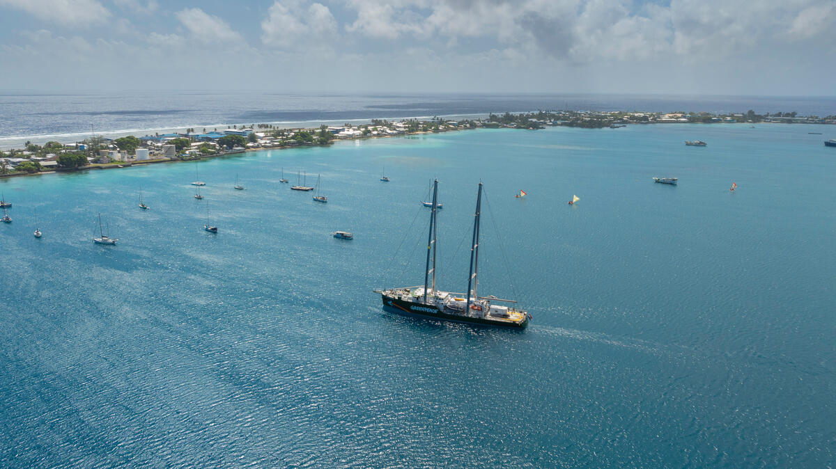
Between March and April, we traveled on the Greenpeace flagship vessel, the Rainbow Warrior, throughout the Marshall Islands, including to three northern atolls that bear the most severe scars of Cold War nuclear weapons testing:
- Enewetak atoll, where, on Runit Island, stands a massive leaking concrete dome beneath which lies plutonium-contaminated waste, a result of from a partial “clean-up” of some of the islands after the nuclear tests
- Bikini atoll, a place so beautiful, yet rendered uninhabitable by some of the most powerful nuclear detonations ever conducted;
- And Rongelap atoll, where residents were exposed to radiation fallout and later convinced to return to contaminated land, part of what is now known as Project 4.1, a U.S. medical experiment to test humans’ exposure to radiation.
This isn’t fiction, nor distant past. It’s a chapter of history still alive through the environment, the health of communities, and the data we’re collecting today. Each location we visit, each sample we take, adds to a clearer picture of some of the long-term impacts of nuclear testing—and highlights the importance of continuing to document, investigate, and attempt to understand and share these findings.
These are our field notes from a journey through places that hold important lessons for science, justice, and global accountability.
Our mission: why are we here?
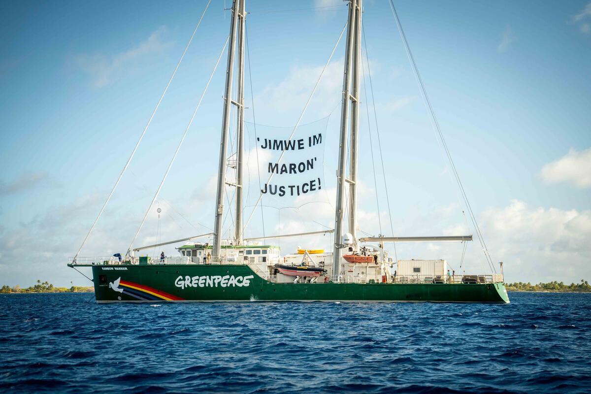
With the permission and support of the Marshallese government, a group of Greenpeace science and radiation experts, together with independent scientists, are in the island nation to assess, investigate, and document the long-term environmental and radiological consequences of nuclear weapons testing in the Marshall Islands.
Our mission is grounded in science. We’re conducting field sampling and radiological surveys to gather data on what radioactivity remains in the environment – isotopes such as caesium-137, strontium-90 and plutonium-239/240. These substances are released during nuclear explosions and can linger in the environment for decades posing serious health risks, such as increased risk of cancers in organs and bones. But this work is not only about radiation measurements, it is also about bearing witness.
We are here in solidarity with Marshallese communities who continue to live with the consequences of decisions made decades ago, without their consent and far from the public eye.
Stop 1: Enewetak Atoll – the dome that shouldn’t exist

In 1954, fallout from Castle Bravo blanketed Rongelap atoll in radioactive ash—fine, white powder that children played in, thinking it was snow. The U.S. government waited three days to evacuate residents, despite knowing the risks. When they were allowed to return three years later, it was a contaminated environment. The exposure caused severe health impacts: thyroid cancers, birth defects such as “jellyfish babies”, miscarriages, and more. © Greenpeace / Chewy C. Lin
At the far western edge of the Marshall Islands is Enewetak. The name might not ring a bell for many, but this atoll was the site of 43 U.S. nuclear detonations. Today, it houses what may be one of the most radioactive places in the world: the Runit Dome.
Once a tropical paradise thick with coconut palms, now Runit Island is capped by a massive concrete structure the size of a football field. Under this dome—cracked, weather-worn, and only 46 centimeters thick in some places—lies 85,000 cubic meters of radioactive waste. These substances are not only confined to the crater—they are also found across the island’s soil, rendering Runit Island uninhabitable for all time. The contrast between what it once was and what it has become is staggering. We took samples near the dome’s base, where rising sea levels now routinely flood the area.
We collected coconut from the island which will be processed and prepared in the Rainbow Warrior’s onboard laboratory. Crops such as coconut are a known vector for radioactive isotope transfer, and tracking levels in food sources is essential for understanding long-term environmental and health risks. The local consequences of this simple fact are deeply unjust. While some atolls in the Marshall Islands can harvest and sell coconut products, the people of Enewetak are prohibited from doing so because of radioactive contamination. They have lost not only their land and safety but also their ability to sustain themselves economically. The radioactive legacy has robbed them of income and opportunity.
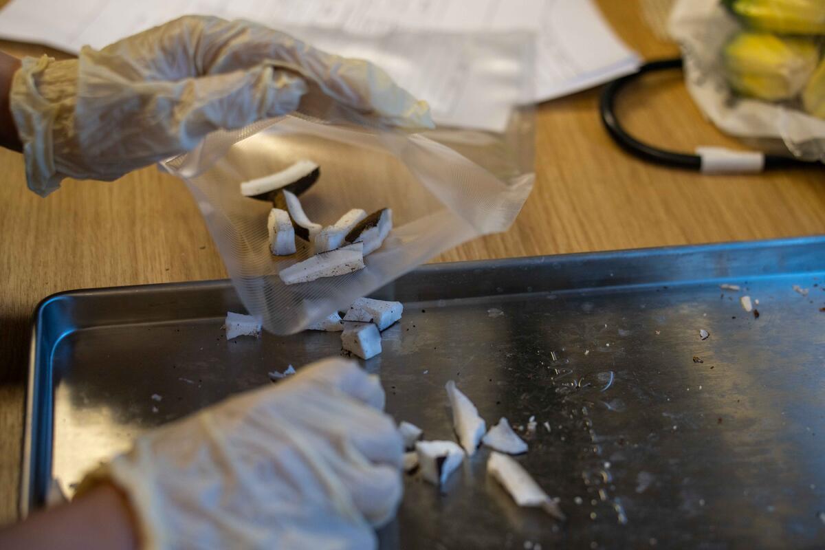
As part of the Marshall Islands ship tour, Greenpeace radiation experts and independent scientists were in Rongelap to sample soil and foodstuffs on the islands that could become food if people came back. © Greenpeace / Chewy C. Lin
One of the most alarming details about this dome is that there is no lining beneath the structure – it is in direct contact with the environment – while containing some of the most hazardous long lived substances ever to exist on planet earth. It was never built to withstand flooding, sea level rise, and climate change. The scientific questions are urgent: how much of this material is already leaking into the lagoon? What are the exposure risks to marine ecosystems and local communities?
We are here to help answer questions with new, independent data, but still, being in the craters and walking on this ground where nuclear Armageddon was unleashed, is an emotional and surreal journey.
Stop 2: Bikini – a nuclear catastrophe, labeled “for the good of mankind”
Unlike Chernobyl or Fukushima, where communities were devastated by catastrophic accidents, Bikini tells a different story. This was not an accident. The nuclear destruction of Bikini was deliberate, calculated, and executed with full knowledge that entire ways of life were going to be destroyed.
Bikini atoll is incredibly beautiful and would look idyllic on any postcard. But we know what lies beneath: the site of 23 nuclear detonations, including Castle Bravo, the largest ever nuclear weapons test conducted by the United States.
Castle Bravo alone released more than 1,000 times the explosive yield of the Hiroshima bomb. The radioactive fallout massively contaminated nearby islands and their populations together with thousands of U.S. military personnel. Bikini’s former residents were forcibly relocated in 1946 before nuclear testing began, and with promises of a safe return. But the atoll is still uninhabited and most of the new generations of Bikinians have never seen their home island. As we stood deep in the forest next to a massive concrete blast bunker, reality hit hard – behind its narrow lead-glass viewing window, U.S. military personnel once watched the evaporation of Bikini lagoon.
On our visit we notice there’s a spectral quality to Bikini. The homes of the Bikini islanders are long gone. In its place now stand a scattering of buildings left by the U.S. Department of Energy: rusting canteens, rotting offices, sleeping quarters with peeling walls, and traces of the scientific experiments conducted here after the bombs fell.
On dusty desks we found radiation reports, notes detailing crop trials, and a notebook meticulously tracking the application of potassium to test plots of corn, alfalfa, lime, and native foods like coconut, pandanus, and banana. The potassium was intended to block the uptake of caesium-137, a radioactive isotope, by plant roots. The logic was simple: if these crops could be decontaminated, perhaps one day Bikini could be repopulated.
We collected samples of coconuts and soil—key indicators of internal exposure risk if humans were to return. Bikini raises a stark question: what does “safe” mean, and who gets to decide? The U.S. declared parts of Bikini habitable in 1970, only to evacuate people again eight years later after resettled families suffered from radiation exposure. The science is not abstract here. It is personal. It is human. It has real consequences.
Stop 3: Rongelap – the setting for Project 4.1
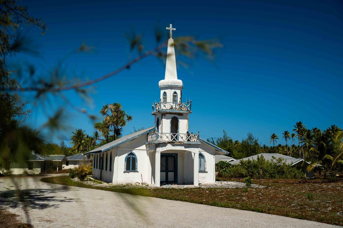
The Rainbow Warrior arrived at the eastern side of Rongelap atoll anchoring one mile from the center of Rongelap Island, the church spire and roofs of “new” buildings reflecting the bright sun. In 1954, fallout from the Castle Bravo nuclear detonation on Bikini blanketed this atoll in radioactive ash—fine, white powder that children played in, thinking it was snow. The U.S. government waited three days to evacuate residents, despite knowing the risks. The U.S. government declared it safe to return to Rongelap in 1957 – but it was a severely contaminated environment. The very significant radiation exposure to the Rongelap population caused severe health impacts: thyroid cancers, birth defects such as “jellyfish babies”, miscarriages, and much more.
In 1985, after a request to the US government to evacuate was dismissed, the Rongelap community asked Greenpeace to help relocate them from their ancestral lands. Using the first Rainbow Warrior, and over a period of 10 days and three trips, 350 residents collectively dismantled their homes bringing everything with them – including livestock, and 100 metric tons of building material – where they resettled on the islands of Mejatto and Ebeye on Kwajalein atoll. It is a part of history that lives on in the minds of the Marshallese people we meet in this ship voyage – in the gratitude they still express, the pride in keeping the fight for justice, and in the pain of still not having a permanent, safe home.

Now, once again, we are standing on their island of Rongelap, walking past abandoned buildings and rusting equipment, some of it dating from the 1980s and 1990s – a period when the U.S. Department of Energy launched a push to encourage resettlement declaring that the island was safe – a declaration that this time, the population welcomed with mistrust, not having access to independent scientific data and remembering the deceitful relocation of some decades before.
Here, once again we sample soil and fruits that could become food if people came back. It is essential to understand ongoing risks—especially for communities considering whether and how to return.
This is not the end. It is just the beginning

Our scientific mission is to take measurements, collect samples, and document contamination. But that’s not all we’re bringing back.
We carry with us the voices of the Marshallese who survived these tests and are still living their consequences. We carry images of graves swallowed by tides near Runit Dome, stories of entire cultures displaced from their homelands, and measurements of radiation showing contamination still persists after many decades. There are 9,700 nuclear warheads still held by military powers around the world – mostly in the United States and Russian arsenals. The Marshall Islands was one of the first nations to suffer the consequences of nuclear weapons – and the legacy persists today.
We didn’t come to speak for the Marshallese. We came to listen, to bear witness, and to support their demand for justice. We plan to return next year, to follow up on our research and to make results available to the people of the Marshall Islands. And we will keep telling these stories—until justice is more than just a word.
Kommol Tata (“thank you” in the beautiful Marshallese language) for following our journey.
Shaun Burnie is a senior nuclear specialist at Greenpeace Ukraine and was part of the Rainbow Warrior team in the Marshall Islands.


