


What seemed like a tense meteorological face-off all winter – between persistent blasts of snow and cold in the Eastern U.S. and unsettling warmth and dryness out West – has devolved into a no-punches-pulled weather brawl. It’s a challenge just to keep score, much less make sense of it all, but we’ll do our best to put this head-spinning round of mid-March Madness in the U.S. weather into perspective. Here’s a capsule summary of what’s been happening and what’s on tap:
- Ferocious cold-front winds knocked out power to more than a million customers in and around Ohio on Friday, March 13.
- Winter wildfire has scorched over 700,00 acres in Nebraska — an area about the size of Rhode Island — since Thursday, including the state’s largest blaze in modern history.
- One of the Midwest’s most intense blizzards in recent decades swept from Iowa and Minnesota into the Great Lakes from Sunday into Monday, dumping snow measured in feet in some areas.
- Severe thunderstorms prowled the mid-Mississippi Valley and mid-South late Sunday, and the severe weather – with a risk of strong tornadoes – was heading toward the mid-Atlantic on Monday.
- Hawaii has been hammered by relentless downpours that are setting multiday and monthly records, especially in Maui.
- Summerlike heat will build across much of the Western and central U.S. by late week, likely topping 100°F in Los Angeles, Las Vegas, and Phoenix and smashing records for March (and even April!) in many spots. The all-time U.S. March heat record of 108°F at Rio Grande City, Texas, on March 30, 1954, is in serious jeopardy.

As implied in Fig. 1 above, the tableau of dramatic weather events is related to a series of troughs (blue dips) and ridges (orange bumps) in the jet stream. As energy propagates around the world through the northern and southern polar jet streams, it sometimes races from west to east in so-called zonal flow that’s often dry and uneventful. At other times, the flow buckles into the sharp troughs and ridges we’re now seeing.
By late this week, the standout feature will be an extraordinarily strong and warm upper ridge over the Southwest United States – one that would be close to record-setting-strong in May, never mind March.
Weather is naturally variable, and the eye-popping weather now playing out from Pacific to Atlantic is so variegated and far-reaching that it’s impossible to identify a single cause. After the dust has settled, we can expect climate scientists to carry out multiple attribution studies to determine how the odds of one or more of these high-impact events, or the broader atmospheric pattern (including the massive Southwest ridge about to take shape), have been affected by planetary warming. But if climate change isn’t solely to blame for what’s happening right now, its fingerprints are certainly in the mix, as we’ll touch on below.
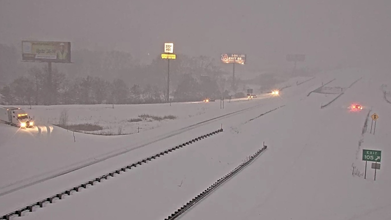
Historic blizzard belting northern Michigan and northern Wisconsin
An intense blizzard with heavy snow and powerful winds labeled a “severe to historic snowstorm” by the National Weather Service in Marquette, Michigan, began blasting northern Michigan and northern Wisconsin on Sunday morning. As of 8 a.m. EDT Monday, snow amounts in excess of 30 inches had fallen in portions of northern Wisconsin and Michigan’s Upper Peninsula and Northern Lower Michigan. Freezing rain brought up to a half-inch of ice accumulation in northern Lower Michigan, from roughly Gaylord to Alpena, with power outages affecting over 120,000 customers on Monday morning.
Snow accumulations from the blizzard were slightly lower than originally forecast, the Weather Service said, because stronger-than-expected winds were fracturing the snow grains as they fell, resulting in a more compact snow with a snow-to-liquid ratio of 6:1 (10:1 is more common). The heavy weight of snow on roofs will be a concern for roof collapses. Northerly winds blowing off Lake Superior at Grand Marais, Michigan, were sustained at 59 mph, gusting to 69 mph, at 8:50 a.m. EDT Monday. Significant wave heights on the lake were expected to reach 20-30 feet this afternoon, resulting in significant shoreline erosion in regions where the wave action is able to break up the ice.
Heavy snowfall, whiteout conditions, and high winds have impacted northern Wisconsin; Wausau, Wisconsin, recorded 23.4 inches of snow in 24 hours ending Monday morning. The Wisconsin State Patrol reported that in the 24 hours ending at 11 a.m. CDT, there were 92 crash investigations (11 with injury), 225 vehicle runoffs, and 188 motorist assists.

Deadly severe weather prowls the Central and Eastern United States
A few days ahead of the blizzard, a similar buckle in the jet stream tapped into a much warmer, moister air mass, leading to a major multiday episode of severe weather. As noted by Steve Bowen at Gallagher Re, at least 70 tornadoes have been confirmed for the period March 10-12, and damage from the severe weather onslaught will be in the billions.
The worst of the tornado-producing supercell thunderstorms on March 10 spawned four tornadoes and huge hail as it moved from far northeast Illinois into far northwest Indiana, killing three people. As recently confirmed by severe weather researcher Victor Gensini at Northern Illinois University, one of the hailstones that fell in that storm weighed 16.5 ounces and had a diameter of 7.125 inches – far larger than the state record of 4.75 inches.
On Friday, an unexpectedly intense blast of high winds ripped across northern Illinois, Indiana, and Ohio. More than a million customers were without power by late Friday, March 13, including more than half a million in Ohio. American Electric Power called it the region’s worst outage since a notorious derecho struck on June 29, 2012. There are signs that a sting jet – a compact bundle of jet-stream winds that dips to the surface while wrapping around a strengthening center of low pressure – may have led to some of the fiercest gusts.
Peak gusts measured on Friday included:
Cleveland, Ohio: (Burke Lakefront Airport): 85 mph
Lorain, Ohio: 77 mph
Toledo, Ohio: 69 mph
Muncie, Indiana: 67 mph
Chicago, Illinois: (O’Hare Int’l Airport): 64 mph
Indianapolis, Indiana: 62 mph
Yet another round of high winds arrived on Sunday, March 15, this time along a thunderstorm squall line plowing through the Mississippi Valley. After filtering out duplicates, more than 300 preliminary reports of severe wind gusts of at least 58 mph had been recorded by the NOAA/NWS Storm Prediction Center by Monday morning, including many reports of trees and power lines knocked down.
The center also flagged a risk of severe weather on Monday along the U.S. Eastern Seaboard from Florida to New York. A moderate risk area (level 4 of 5) was in place at midday from central South and North Carolina to the Washington, D.C., area, where the highest odds of tornadoes and damaging thunderstorm winds were expected. At least a couple of strong and/or long-track tornadoes are possible, the center warned.

Western Nebraska scorched by largest wildfire in state history
Moderate to extreme drought covers over 90% of Nebraska, which had its second-warmest and fourth-driest winter on record. Late afternoon on Thursday, March 12, 2026, the Morrill Wildfire started in Morrill County, Nebraska, in a region of extreme drought. At the time, temperatures were in the low 70s, relative humidity was a very dry 15-20%, and sustained winds were very high — sustained at 44 mph, gusting to 54 mph. According to InciWeb, fuel moistures were at historic low levels. Despite the heroic efforts of firefighters, the fire traveled approximately 70 miles in less than 12 hours, ripping through sparsely populated grasslands.
One person has been killed by the Morrill Fire, which had burned 573,000 acres as of Monday morning. This makes the fire the state’s largest on record, and unofficially one of the top-10 largest fires in the continental U.S. in the past 100 years.
Top 10 largest continental U.S. wildfires of the past 100 years
| Acreage | State | Year | Fire name | Fatalities |
| 1,058,482 | TX/OK | Feb-Mar 2024 | Smokehouse Creek | 2 |
| 1,032,648 | California | Aug 2020 | August Complex | 1 |
| 963,309 | California | Jul 2021 | Dixie | 1 |
| 907,000 | Texas | Mar 2006 | East Amarillo Complex | 12 |
| 794,000 | WY/MT/ID | Jul 1988 | Yellowstone fires of 1988 | 1 |
| 779,000 | OK | Mar 2017 | NW Oklahoma Complex | 0 |
| 652,000 | ID/NV | Jul 2007 | Murphy Complex Fire | 0 |
| 573,000 | NE | Mar 2026 | Morrill | 1 |
| 558,000 | OR | Jul 2012 | Long Draw | 0 |
| 538,000 | AZ/NM | Jul 2011 | Wallow Fire | 0 |
| 500,000 | OR | Jul 2002 | Biscuit | 0 |
Three other large fires were also burning in Nebraska on Monday morning: the Cottonwood Fire (122,000 acres), the Road 203 Fire (36,000 acres), and the Anderson Bridge Fire (16,000 acres).
According to the Hotshot Wake Up, the record fires in Nebraska have left firefighting resources thin in the U.S. right now, particularly for firefighting aircraft. With the incredible Southwest U.S. heat wave coming later this week, a lack of firefighting resources could be a significant problem if major fires erupt.
The DOGE cuts to the U.S. Forest Service aren’t helping the situation. The U.S. Forest Service is lagging behind hazardous fuels treatment levels relative to previous years, and budget and staffing cuts made by DOGE in the first half of 2025 resulted in a loss of 1,400 qualified wildland firefighting personnel.
Maui rainfall record KO’d by Kona low
On the other side of the precipitation spectrum, Hawaii has been plagued by a persistent “Kona low” – winter storms so named because of the soggy westerly (Kona) winds they bring. Several Kona storms typically affect the state each winter, but this one has been exceptionally strong, especially on the island of Maui. Rainfall storm totals across Hawaii through Sunday morning, March 15, as compiled by Hawaii News Now include 19.27 inches at Schofield Barracks, Oahu; 25.45 inches at Mauna Loa, Big Island; and 44.35 inches at the Kula 1 station on Maui. Amid widespread reports of damage across the state, Hawai’i Volcanoes National Park was closed through the weekend. “Rain, wind, falling trees and power outages continue,” the park warned on Sunday.
On Friday and Saturday, March 13-14, the airport at Kahului on Maui reported 13.22 inches of rain. That swamped the previous two-day record of 9.03 inches (Dec. 21-22, 1955) at Kahului, where weather records extend back to 1905. With March only half over, Kahului has already had the wettest month in its 121-year weather history.
Summer heat arriving with the spring equinox
This week of truly wild U.S. weather is on track to culminate in an exceptionally unusual event: a summerlike heat wave that will pose distinct health dangers in some of the nation’s biggest cities. The heat and dryness will also set the stage for longer-term wildfire and water risks throughout the U.S. West.
The upper-level ridging that’s recurred for much of the winter over the Southwest will intensify this week into a behemoth that is expected to set a staggering number of heat records over the southwestern portion of the nation by late week – including on Friday, March 20, the spring equinox. Forecast models have come into increasing agreement that this air mass will heat and expand so dramatically that the height of the 500-millibar surface (roughly the midpoint of the atmosphere, with half of its mass above that level and half below it) will reach a level never before documented prior to May (much less March!) across the Desert Southwest.
Obviously, and fortunately, there won’t be May or June sunlight to exacerbate the heat. Yet the sheer intensity of the ridge will still allow for stunningly hot readings at the surface, and the predicted persistence of the ridge will allow the heat impacts to build to dangerous levels, especially in cities. Extreme heat watches and warnings were already in place on Monday from southeast California and southern Nevada into southern Arizona. Along with the immediate health risks it’ll bring, the dry heat will severely deplete the already paltry snowpack across most of the U.S. West, both through melting and sublimation (evaporation). This will lay the groundwork for enhanced wildfire and water-supply troubles later this spring and summer if substantial moisture doesn’t arrive in April.
Many of the high temperatures expected later this week would be typical readings (or even above average) if they occurred in early June. Not only will many dozens of towns and cities shatter all-time records for March, but some states will likely do the same, according to weather historian Chris Burt, author of “Extreme Weather: A Guide and Record Book.” All-time (year-round) state heat records are maintained by the State Climate Extremes Committee via the NOAA National Centers for Environmental Information. This committee doesn’t evaluate monthly state records, but Burt has done so, painstakingly, for years. Below (in degrees Fahrenheit) are a few of the state and city records for March – many if not most of them destined to fall – that Burt will be keeping an eye on this week.
All-time March records for selected states
Wyoming: 86°, Pine Bluffs, March 20, 1907
Colorado: 96°, Holly, March 19, 1907
New Mexico: 99°, Roswell No. 2, March 31, 1946
Utah: 93°, La Verkin, March 21, 2004, and Lytle Ranch, March 22, 2004
Arizona: 104°, Yuma Quartermaster Station, March 21, 2004
Nevada: 100°, Laughlin, March 17, 2007, and Bunkerville, March 18, 2007
California: 107°, Mecca Fire Station, March 21, 2004
Oregon: 91°, Dayville, March 31, 1911
Idaho: 85°, Grand View, March 29, 1966, and Swan Falls, March 30, 1960
All-time March records for selected cities (together with the highs predicted as of midday Monday by the National Weather Service for Wednesday, Thursday, and Friday, March 18-20):
Cheyenne, Wyoming: 77° on March 29, 1879; forecast 74°, 76°, 77°
Denver, Colorado: 84° on March 26, 1971; forecast 79°, 82°, 85°
Salt Lake City, Utah: 80° on March 31, 2012; forecast 78°, 80°, 80°
Albuquerque New Mexico: 85° on March 26, 1971; forecast 84°, 89°, 89°
Phoenix, Arizona: 100° on March 26, 1988; forecast 102°, 105°, 106°
Las Vegas, Nevada: 93° on March 26, 2022; forecast 96°, 98°, 100°
Palm Springs, California: 104° on March 31, 1966; forecast 106°, 108°, 110°
Los Angeles, California (downtown): 99° on March 29, 1871; forecast 97°, 99°, 98°
San Francisco, California (downtown): 87° on March 11, 2005; forecast 87°, 87°, 86°
Reno, Nevada: 83° on March 31, 1966; forecast 85°, 86°, 86°
Boise, Idaho: 82° on March 26, 1877; forecast 78°, 80°, 80°
A couple of analogs worth noting
The unfolding setup for record heat has some elements in common with two other exceptional heat waves of recent years.
(1) The great “warm wave” of March 2012
The jaw-dropping departures predicted at the surface and aloft bring to mind the heat wave of March 2012. Although that event was most exceptional across the Midwest and East rather than the Southwest, there are uncanny similarities in the absurdity of the warmth observed then and predicted now. As noted in Jeff Masters’ summary blog post published at Weather Underground on April 10, 2012, the month of March 2012 saw the most daily records broken at gold-standard, century-long U.S. climate stations for any month since July 1936. Many records were broken by 10-20°F; at least 44 were broken by more than 22°F; and four stations broke a record for the date by 30°F or more. In 21 cases, a daily low temperature was warmer than the record high for the date. When more typical freezes returned in April, early-blossoming fruit crops in Michigan suffered millions of dollars in damage.
An initial assessment led by Martin Hoerling at the NOAA Earth System Research Laboratory concluded that human-produced warming likely contributed on the order of 5% to 10% of the magnitude of the heat wave on March 12-23, 2012. The report added: “the probability of heat waves is growing as [greenhouse-gas]-induced warming continues to progress.” (Ominously, the March heat of 2012 segued into a drought-ravaged summer across much of the United States. This happened at the tail end of two years of La Niña conditions – exactly where we are right now.)
(2) The Pacific Northwest heat wave of June 2021
An extraordinarily strong upper-level high in the Pacific Northwest in late June and early July 2021 led to a catastrophic heat wave, taking an estimated 1,400 lives in the far northwest U.S. and far southwest Canada. Seemingly impossible all-time heat records were set in Portland, Oregon (116°), Salem, Oregon (117°F), Seattle, Washington (108°F), and most tragically, Lytton, British Columbia – which broke Canada’s national heat record for three consecutive days, hitting a peak of 49.6°C (121.3°F) on June 29 before being largely destroyed by wildfire on June 30.
A rapid-release analysis from World Weather Attribution in July 2021 concluded that “an event such as the Pacific Northwest 2021 heat wave is still rare or extremely rare in today’s climate, yet would be virtually impossible without human-caused climate change. As warming continues, it will become a lot less rare.”
In a post at Weather West on March 1, climate scientist Daniel Swain noted that the extreme upper ridge behind the 2021 heat wave was intensified by a powerful North Pacific storm upstream whose warmth and moisture led to huge amounts of heat being added to the air via condensation. Similarly, Swain argued, the powerful Kona storm giving parts of Hawaii record rainfall is generating upper-level warmth that will translate downstream via a moist conveyor belt and feed into the upper-level high set to intensify over the U.S. Southwest later this week, in what Swain called a “somewhat complex and counterintuitive process.”
More broadly, it’s well established that the heaviest precipitation events in many parts of the world are getting heavier, as the planet warms and more rain- and snow-generating water vapor evaporates from the world’s oceans. Likewise, that global warmth is making droughts more powerful at parching the landscape when they develop, and a dry landscape warms up more readily when the sun hits it.
These factors only add to the ominousness of the summerlike heat wave that’s fast approaching.
![]()