


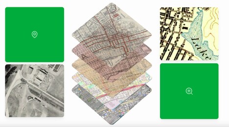
Pastmaps is a digital platform designed to support historical research through access to a large archive of high-resolution historical maps. The tool offers researchers, educators, and history enthusiasts the ability to explore geographic changes over time using intuitive search and navigation features.
Users can overlay, zoom, and compare maps from various regions and periods, making it useful for fields such as urban planning, archaeology, genealogy, and academic history. Pastmaps also includes built-in tools to annotate, organize, and reference map data for further study or presentation. The platform aims to streamline the research process by making rare or fragmented map collections digitally accessible and searchable. With its balance of depth and usability, Pastmaps can serve both casual exploration and rigorous professional inquiry.
Image Credit: Pastmaps