


March 12, 2026
5 min read

Why ships in the Strait of Hormuz can’t trust their navigation screens
GPS spoofing is distorting vessel positions and deepening the risk in one of the world’s most important shipping lanes
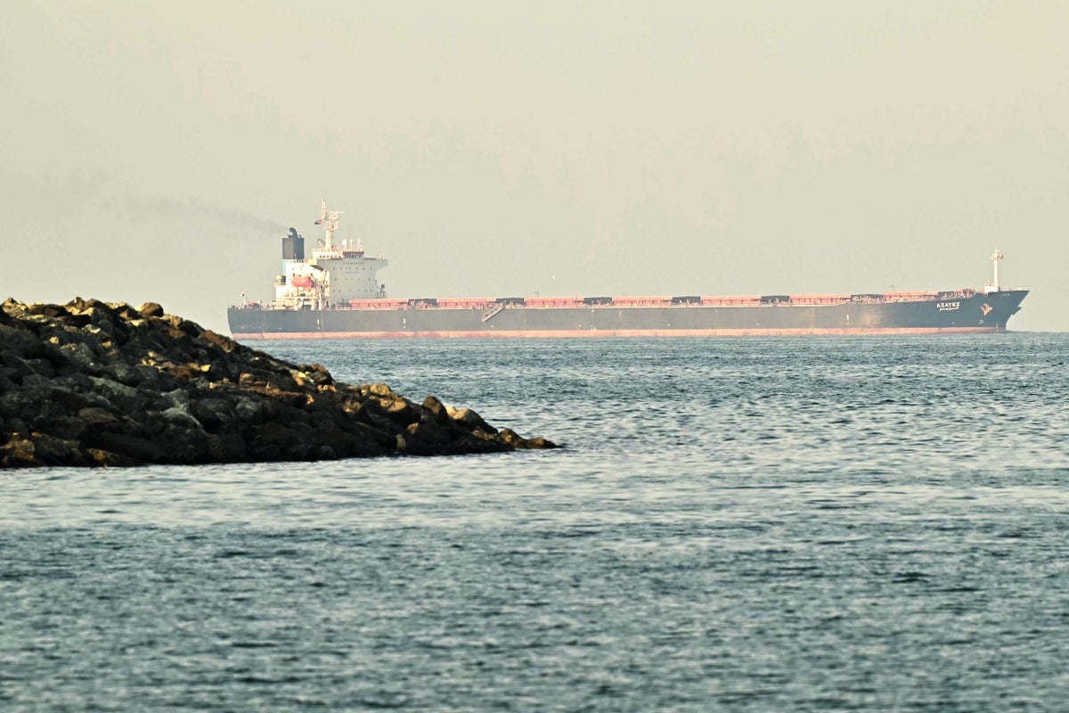
Ships crossing the Strait of Hormuz increasingly face GPS spoofing that wreaks havoc on their navigational equipment.
Giuseppe CACACE/AFP via Getty Images
When ships enter the Strait of Hormuz between Iran and the Arabian Peninsula, their navigation screens report impossible things. Supertankers circle over dry land. Cargo vessels cross through airports. Container ships drift through a nuclear power plant. In the two weeks since the U.S. and Israel launched attacks against Iran, thousands of vessels have experienced navigation interference in the Persian Gulf. Commercial shipping through the strait, which carries roughly 20 percent of the world’s oil, has nearly ground to a halt.
Though rocket and drone attacks are also to blame, another major hazard is GPS (Global Positioning System) spoofing—the transmission of counterfeit satellite navigation signals. The tactic exposes an urgent vulnerability in the global supply chain: the fundamental technology that guides the modern world is remarkably fragile. Since at least June 2025, in one of the planet’s vital maritime passages, crews have periodically been forced to steer by eye rather than rely on their usual satellite-linked tools. The recent outbreak of war has now made that much worse.
“I’m quite certain that it is the Iranians who are doing this spoofing,” says Todd Humphreys, a professor of aerospace engineering at the University of Texas at Austin. The spoofing doesn’t just interfere with ships’ own GPS; it also causes their automatic identification system, or AIS, to broadcast false locations, often showing ships tracing large circles even when they aren’t moving. Researchers used to jokingly call these “crop circles,” Humphreys says. He suspects the circles are simply a default movement pattern in certain low-cost spoofing devices available on the open market. “But neither the spoofer itself nor the actual ship is going in circles,” he says. The spoofer likely sits on a tall tower or a tethered balloon called an aerostat on the Iranian coast as it broadcasts signals.
On supporting science journalism
If you’re enjoying this article, consider supporting our award-winning journalism by subscribing. By purchasing a subscription you are helping to ensure the future of impactful stories about the discoveries and ideas shaping our world today.
“A regular GPS receiver pulls in signals from satellites way up in medium Earth orbit, 20,000 kilometers away,” Humphreys says. “A spoofer pretends to be all of those signals at once, and it comes from a single antenna.”
The real danger in the Strait of Hormuz isn’t that ship captains can’t find their own positions. “A seasoned crew knows their equipment is compromised once they start seeing circular patterns indicating that they are on land when they’re not,” Humphreys says. They can fall back on visual cues—binoculars, radar decoupled from GPS, shoreline matching. But the critical problem is that every ship’s AIS beacon is also fed by its compromised GPS receiver. The false location, Humphreys says, “is picked up by AIS receivers across the coast. And that’s what other ships see.”
A single ship could probably navigate the strait, but on the average day, 130 to 150 vessels—many of them immense—transit the Strait of Hormuz, which is only 21 miles across at its narrowest point. But when a captain looks at electronic chart displays and sees hundreds of circling ships in false locations, they don’t know where the others are, how fast they are moving or what they are about to do. “It’s just chaos on your electronic chart display,” Humphreys says. “These are enormous ships that take kilometers to slow down and change direction. Very few captains would be willing to put a supertanker through that narrow strait.”
Spoofing has evolved into a potent weapon in recent years. When Humphreys built the first publicly acknowledged civilian GPS spoofer in 2008, military officials initially dismissed the threat as manageable. But the first spoofing observed in the wild came in 2016, when Russia began deploying spoofers around sites associated with its president Vladimir Putin’s travels—likely to protect against drone assassinations, Humphreys says. Israel deployed the tactic extensively in 2024 to defend against Iranian and Hezbollah missiles, leading to severe disruptions to everything from dating apps to delivery services.
What makes the Strait of Hormuz situation uniquely challenging is that shipping runs on outdated GPS technology. “The receivers themselves are out of date by maybe 15 years,” Humphreys says. “Some of them only pull in signals from the U.S. Global Positioning System on a single frequency,” whereas a smartphone “has a chip inside of it that can pull in four different [satellite] constellations and two or three different frequencies.” Antennas that are designed to resist spoofing and receivers that can use several satellite constellations already exist, and some newer ships and aircraft are beginning to adopt them. But retrofitting these systems across large existing fleets remains slow and expensive.
The solution may not lie in a single technology. Zak Kassas, a professor of electrical engineering at the Ohio State University, has spent more than a decade developing navigation systems that exploit what he calls “signals of opportunity”—radio transmissions that were never intended for navigation, including transmissions from cellular towers, Starlink satellites and even weather satellites. “When we started, it was sort of a nice thing to have,” he says. “But now it is a pressing need. It could be a life-or-death situation.”
Using only cellular signals, Kassas’s lab has navigated a drone to submeter accuracy and a ground vehicle to near-lane-level precision. In a Department of Defense exercise in the Mojave Desert, they navigated a ground vehicle for nearly five kilometers with just a couple meters of error—by listening to cell towers during intentional GPS jamming. The approach, Kassas says, amounts to “security by diversification.” Because these other signals span a much wider swath of the radio spectrum and are more powerful than GPS, they are harder to jam or spoof.
But for vessels stranded near the Strait of Hormuz, even improvised work-arounds—an iPad with a better GPS chip, for instance—can become liabilities because insurance hasn’t approved them. “Insurance companies that insure ships against collisions or accidents would do an analysis of everything that led up to a collision,” Humphreys says. If the crew had relied on any unapproved system, “the insurance payout probably wouldn’t be forthcoming.” So otherwise reliable stopgap measures can sit unused just when crews need them most.
In theory, international law should prevent spoofing. The constitution of the International Telecommunication Union prohibits harmful interference with the radio navigation satellite signal band. But the rules still leave militaries enough leeway to jam or spoof when they see the tactical need—provided they are, as far as possible, limiting the damage to everyone else. “Even the United Nations recognizes that sometimes it’s perfectly legitimate for a country to send out radio signals that are harmful to other countries,” Humphreys says. Israel, Russia and Ukraine have done so. The U.S. jammed GPS signals before its operation to capture Nicolás Maduro in Venezuela. “It seems to be a free-for-all now,” Humphreys says. “And that is to the long-term detriment of transportation across the globe.”
It’s Time to Stand Up for Science
If you enjoyed this article, I’d like to ask for your support. Scientific American has served as an advocate for science and industry for 180 years, and right now may be the most critical moment in that two-century history.
I’ve been a Scientific American subscriber since I was 12 years old, and it helped shape the way I look at the world. SciAm always educates and delights me, and inspires a sense of awe for our vast, beautiful universe. I hope it does that for you, too.
If you subscribe to Scientific American, you help ensure that our coverage is centered on meaningful research and discovery; that we have the resources to report on the decisions that threaten labs across the U.S.; and that we support both budding and working scientists at a time when the value of science itself too often goes unrecognized.
In return, you get essential news, captivating podcasts, brilliant infographics, can’t-miss newsletters, must-watch videos, challenging games, and the science world’s best writing and reporting. You can even gift someone a subscription.
There has never been a more important time for us to stand up and show why science matters. I hope you’ll support us in that mission.