

Heavy rain is expected to batter large swathes of Australia’s coast as two tropical cyclones bear down on either side of the country.
Cyclone Alfred, off Queensland’s north coast, and Cyclone Bianca, off the north coast of Western Australia, are both moving southwards after developing from tropical lows in the last 24 hours.
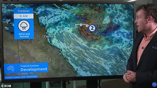
Tropical Cyclone Alfred is gaining strength as it moves nearer to the coast in the Coral Sea, however, it remains well offshore as of Monday morning.
‘There is a risk it will move closer to the central Queensland coast next weekend,’ the Bureau of Meteorology said.
‘On Tuesday, Alfred is forecast to turn southeast and then south while continuing to intensify into the middle of the week.
‘From Thursday, the confidence in the track decreases with the most likely scenario taking Alfred further south through the Coral Sea and remaining well offshore from the Queensland coast.’
If the system does approach the coastline, the Bureau said it is likely to bring heavy rain, strong winds and flash flooding.
Meanwhile, Tropical Cyclone Bianca is situated in the Indian Ocean well to the west northwest of Exmouth in WA and is continuing in a southwest direction.

Tropical Cyclone Alfred is gaining strength as it moves slowly eastwards in the Coral Sea towards communities in North Queensland

The two cyclones either side of Australia have been joined by a low pressure system in the south, set to bring heavy rain
‘It is expected to strengthen during today and Tuesday, and is forecast to move to the south southwest, remaining well offshore from the Western Australian coast,’ the Bureau said.
‘On Wednesday it is expected to start weakening.
‘No direct impacts are expected at any Australian mainland or Island communities,’ the Bureau said of the cyclone off WA.
Weatherzone meteorologist James Wall added a mid latitude low pressure system is also affecting Australia’s south, likely bringing rain later this week.
‘This low pressure system is introducing cooler and fresher westerly winds into southeast Australia in the wake of some hot northerlies,’ he said.
‘This can be seen on satellite images as speckled cloud and is often associated with showers.
‘The dividing line between these air masses is a cold front bringing some thunderstorm activity to parts of eastern Victoria, Tasmania and southeastern parts of NSW.’
Sydney
Tuesday: Cloudy. Medium chance of showers, most likely in the morning and early afternoon. Winds south to southeasterly 20 to 30 km/h becoming light in the late evening. Min 21. Max 25.
Wednesday: Partly cloudy. Slight chance of a shower in the morning and afternoon. Light winds becoming east to northeasterly 15 to 20 km/h during the afternoon then becoming light during the evening. Min 20. Max 28.
Thursday: Mostly sunny. The chance of morning fog in the outer west. Slight chance of a shower in the outer west, near zero chance elsewhere. The chance of a thunderstorm in the outer west in the afternoon and evening. Light winds becoming east to northeasterly 15 to 25 km/h during the day then becoming light during the evening. Min 19. Max 29.

The three systems to Australia’s east, west and south are set to bring widespread rain in the coming days

Tropical Cyclone Bianca is situated in the Indian Ocean well to the west northwest of Exmouth and is continuing in a southwest direction, away from mainland Australia
Melbourne
Tuesday: Mostly sunny. Winds south to southeasterly 15 to 25 km/h becoming light in the late evening. Min 14. Max 27.
Wednesday: Sunny. Light winds becoming north to northwesterly 15 to 25 km/h during the morning then shifting south to southwesterly 20 to 30 km/h during the afternoon. Min 15. Max 34.
Thursday: Partly cloudy. Medium chance of showers, most likely in the evening. Light winds becoming southerly 15 to 25 km/h during the afternoon then becoming light during the evening. Min 17. Max 26.
Brisbane
Tuesday: Partly cloudy. Slight chance of a shower. Light winds becoming southerly 15 to 20 km/h early in the morning then tending southeasterly 20 to 30 km/h in the morning. Min 21. Max 30.
Wednesday: Partly cloudy. Medium chance of showers, most likely in the morning and afternoon. Winds southerly 15 to 20 km/h tending southeasterly 20 to 30 km/h during the morning then becoming light during the evening. Min 22. Max 29.
Thursday: Partly cloudy. Slight chance of a shower. Light winds becoming southeasterly 20 to 30 km/h during the morning then becoming light during the evening. Min 21. Max 30.

Cyclone Alfred, off Queensland’s coast, and Cyclone Bianca, off the coast of Western Australia, are both moving south after developing from tropical lows in the last 24 hours
Perth
Tuesday: Partly cloudy. Slight chance of a shower. Light winds becoming south to southwesterly 15 to 25 km/h in the middle of the day then becoming light in the late evening. Min 17. Max 28.
Wednesday: Partly cloudy. Slight chance of a shower. Winds east to southeasterly 15 to 20 km/h turning south to southwesterly 20 to 30 km/h during the morning. Min 20. Max 35.
Thursday: Partly cloudy. Medium chance of showers in the morning. Winds southerly 15 to 20 km/h increasing to 20 to 30 km/h during the day then turning southeasterly 15 to 20 km/h during the evening. Min 21. Max 31.
Adelaide
Tuesday: Sunny. Winds east to southeasterly 15 to 25 km/h tending east to northeasterly in the morning then becoming light in the evening. Min 16. Max 33.
Wednesday: Partly cloudy. Light winds becoming southwesterly 15 to 25 km/h during the day then turning south to southeasterly during the afternoon. Min 19. Max 32.
Thursday: Partly cloudy. Slight chance of a shower. Winds east to southeasterly 15 to 25 km/h shifting west to southwesterly during the morning then tending south to southwesterly during the evening. Min 17. Max 30.
Hobart
Tuesday: Partly cloudy. Winds west to northwesterly 15 to 20 km/h becoming light before dawn then becoming northwesterly 15 to 20 km/h early in the morning. Min 12. Max 24.
Wednesday: Mostly sunny morning. Slight chance of a shower in the afternoon and evening. Winds northwesterly 15 to 20 km/h shifting south to southwesterly 15 to 25 km/h during the afternoon. Min 14. Max 29.
Thursday: Cloudy. Slight chance of a shower. Winds southerly 15 to 20 km/h shifting east to northeasterly 15 to 25 km/h during the morning then becoming light during the evening. Min 13. Max 23.

Weatherzone warned the souther low could bring ‘some thunderstorm activity to parts of eastern Victoria, Tasmania and southeastern parts of NSW’
Canberra
Tuesday: Cloudy. Winds southeasterly 15 to 20 km/h becoming light before dawn then becoming easterly 15 to 20 km/h in the late afternoon. Min 13. Max 27.
Wednesday: Partly cloudy. Light winds. Min 11. Max 32.
Thursday: Sunny. Light winds. Min 13. Max 33.
Darwin
Tuesday: Partly cloudy. Medium chance of showers, most likely in the late morning and afternoon. The chance of a thunderstorm. Light winds. Min 25. Max 33.
Wednesday: Partly cloudy. Medium chance of showers. The chance of a thunderstorm. Light winds. Min 25. Max 34.
Thursday: Partly cloudy. Medium chance of showers, most likely in the morning and afternoon. The chance of a thunderstorm. Light winds. Min 24. Max 33.