


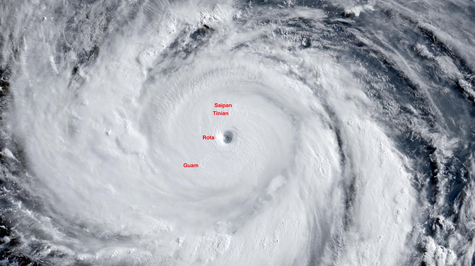
Super Typhoon Bavi blasted through the U.S. Northern Mariana Islands just after sunrise Monday local time (Sunday evening U.S. EDT) as a high-end Category 5 storm with 180 mph (290 km/h) winds, according to the Joint Typhoon Warning Center. Between 6 and 7 p.m. EDT Sunday, the eye of the great storm completely encompassed the small island of Rota (population 1,900), which likely suffered severe to catastrophic damage. Heavy damage was also likely to have occurred south of the eye in northern Guam and to the north, over the islands of Tinian and Saipan. The Japan Meteorological Agency, the official agency responsible for typhoon warnings in the Northwest Pacific, estimated that Bavi’s central pressure at the time was 910 mb, with 125 mph (205 km/h) winds (10-minute average, which is normally substantially lower than the one-minute average used by the Joint Typhoon Warning Center).
12 hours of Himawari-9 visible imagery of Super Typhoon #Bavi traversing through the Marianas. Lots of interesting things to see. The low-level eye spins up to solid body rotation over the course of the day. The eye (still) seemed kind of elliptical, but it's hard to tell for sure.
— Yūnny (they/them) ☀️⛈️☂️🕶️ (@jimmy-yunge.bsky.social) 2026-07-06T12:34:19.995Z
WATCH: The office of Rota Mayor Aubrey Hocog has been destroyed by Super Typhoon #Bavi.
🎥: Kandit News Group pic.twitter.com/7RnK74iLR4— Scott (@RandomHeroWX) July 6, 2026
Bavi was near its maximum potential intensity

Bavi hit Rota at peak intensity: 180 mph (290 km/h) winds with a central pressure of 910 mb. This is quite close to the maximum potential intensity that a tropical cyclone can have under those prevailing atmospheric and oceanic conditions — about 200 mph with a central pressure of 885 mb, according to a graphic from the University of Wisconsin CIMSS. It is quite rare for a hurricane or typhoon to reach its maximum potential intensity — all conditions have to be perfect, and the atmosphere and ocean make up a complex system where perfection is rarely achieved.
Just after Bavi passed through the Northern Mariana Islands, radar imagery from Guam showed that the interior of the west eyewall exhibited a scalloped appearance (Fig. 1) — likely indicating the presence of mesoscale vortices embedded within the eyewall. These tornado-scale circulations were first definitively observed during a hurricane hunter flight I was on in 1989 into Hurricane Hugo (which nearly brought down the aircraft), and have been blamed for some of the extreme damage observed in Category 5 Hurricane Andrew in South Florida in 1992.
Forecast for Bavi
At 8 a.m. EDT Monday, July 6, the Super Typhoon Bavi was a Category 5 storm with 160 mph (260 km/h) winds, according to the Joint Typhoon Warning Center. Bavi had a central pressure of 910 mb, according to the Japan Meteorological Agency. Bavi continues to have favorable conditions for maintaining Category 5 strength: moderate wind shear of 10-15 knots, sea surface temperatures of 30-31 degrees Celsius (86-88°F), with warm waters that extend to great depth (an ocean heat content over 125 kilojoules per square centimeter).

The Joint Typhoon Warning Center is predicting that wind shear will increase to a high level on Tuesday, reaching 20-25 knots. This should result in considerable weakening beginning on Wednesday, with the typhoon dropping to Category 3 strength (120 mph winds) by Friday, July 10, when it will be threatening northern Taiwan and Japan’s Ryukyu Islands.
Bavi will track clockwise around a strong ridge of high pressure that is steering the typhoon, and is expected to deviate from its current west-northwest motion, beginning to bend toward a more northwesterly track by Wednesday. This track should carry the storm near or over northern Taiwan and/or Japan’s Ryukyu Islands on Friday and into China south of Shanghai on Saturday. Though the typhoon’s winds will be weaker when it hits Asia, Bavi will be expanding greatly in size, bringing widespread storm-surge flooding, rainfall, and damaging winds.

Irene Sans contributed to this post.
This <a target=”_blank” href=”https://yaleclimateconnections.org/2026/07/cat-5-super-typhoon-bavi-pounds-the-u-s-northern-mariana-islands-and-guam/”>article</a> first appeared on <a target=”_blank” href=”https://yaleclimateconnections.org”>Yale Climate Connections</a> and is republished here under a <a target=”_blank” href=”https://creativecommons.org/licenses/by-nc-nd/4.0/”>Creative Commons Attribution-NonCommercial-NoDerivatives 4.0 International License</a>.<img src=”https://i0.wp.com/yaleclimateconnections.org/wp-content/uploads/2020/10/ycc-favicon.png?resize=100%2C100&ssl=1″ style=”width:1em;height:1em;margin-left:10px;”>
<img id=”republication-tracker-tool-source” src=”https://yaleclimateconnections.org/?republication-pixel=true&post=139997&ga4=1401ERFF5Q” style=”width:1px;height:1px;”><script> PARSELY = { autotrack: false, onload: function() { PARSELY.beacon.trackPageView({ url: “https://yaleclimateconnections.org/2026/07/cat-5-super-typhoon-bavi-pounds-the-u-s-northern-mariana-islands-and-guam/”, urlref: window.location.href }); } } </script> <script id=”parsely-cfg” src=”//cdn.parsely.com/keys/yaleclimateconnections.org/p.js”></script>