


Mexico City is sinking, and a powerful new orbiting satellite that’s monitoring changes in land levels all across the globe has discovered how quickly this is happening. It’s all thanks to the mission’s innovative dual-frequency band radar.
NISAR, the NASA–ISRO Synthetic Aperture Radar satellite, launched on July 30, 2025 as a joint partnership between NASA and the Indian Space Research Organisation (ISRO). Its mission is to track in real-time surface changes on Earth, from ground subsidence and the retreat of glaciers to and the movement of tectonic plates and the spread of wildfires — all to a precision of within a centimeter.
It has been known since 1925 that much of the city, home to 20 million people, is sinking at a rate of up to 14 inches (35 centimeters) per year. This is the result of the city being built above an aquifer, or an underground layer of permeable rock and sand, left behind by an ancient lakebed — and the resulting groundwater pumping and the weight of its urban sprawl is compressing those sedimentary layers. The result is damage to buildings and infrastructure, such as the Mexico City Metro system.
“NISAR’s long-wavelength L-band radar will make it possible to detect and track land subsidence in more challenging and densely vegetated regions such as coastal communities where they may have the compounding effect of both land subsidence and sea level rise,” said Craig Ferguson, who is NISAR’s deputy manager at NASA Headquarters in Washington, D.C.
NISAR is one of the most powerful radars ever launched into space. L-band refers to the microwave frequency of 1–2 gigahertz (GHz), but the satellite also carries an S-band radar that operates at longer frequencies of 2–4 GHz. NASA built the L-band radar that is sensitive to changes in bedrock and ice, and which was utilized in this study of Mexico City, while ISRO built the S-band radar that is sensitive to changes in vegetation.

Both L- and S-band radars are synthetic aperture radars. As the spacecraft moves in orbit around Earth, covering the entire surface every 12 days, its motion results in it scanning a much larger area on the ground than the size of its true aperture. Hence it has a “synthetic” aperture and blurring of the resulting radar image is avoided by firing thousands of radar pulses per second. NISAR is the first mission to carry both an L-band and an S-band synthetic aperture. The radar reflections are captured by NISAR’s 39-foot (12-meter) drum-shaped collector, the largest radar antenna reflector NASA has ever built.
“We’re going to see an influx of new discoveries from all over the world, given the unique sensing capabilities of NISAR and its consistent global coverage,” said Bekaert.
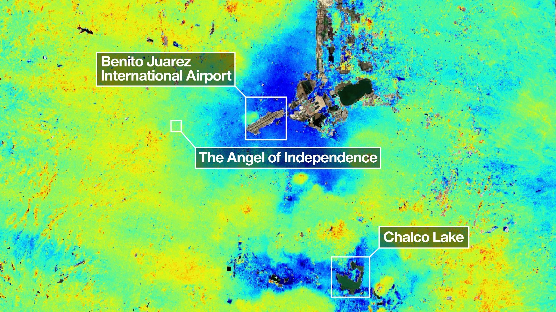
The radar image of Mexico City looks like a contradictory splash of blue and yellow paint. These colors are false, designed to highlight shifts in the ground. Dark blue represents parts of the city that have subsided by more than 0.5 inches (2 cm) during the period between October 2025 and January 2026, which is Mexico’s dry season. Yellow and green areas are residual noise. This would be expected to decrease as NISAR makes more passes over Mexico and the signal-to-noise ratio improves.
“Images like this confirm that NISAR’s measurements align with expectations,” said Ferguson.
As one of the quickest subsiding capitals in the world, Mexico City is therefore the perfect opportunity for NISAR to test its skills. To place its rate of subsidence into context, the towering Angel of Independence — a 118-foot-tall (36-meter-tall) spire with a golden statue of an angel perched atop that commemorates Mexico earning its independence — on the Paseo de la Reforma in the heart of Mexico City has required 14 new steps to be added to it since its construction in 1910.